Each of us in the Communication team works 2 shifts a day in the tower. Today for example I worked the morning shift with Pete and the afternoon shift with Crispin then Callum and Crispin took over for the evening shift and Pete had “second night gash” in the evening.
A typical shift in the tower will involve flight following and base radio communications.
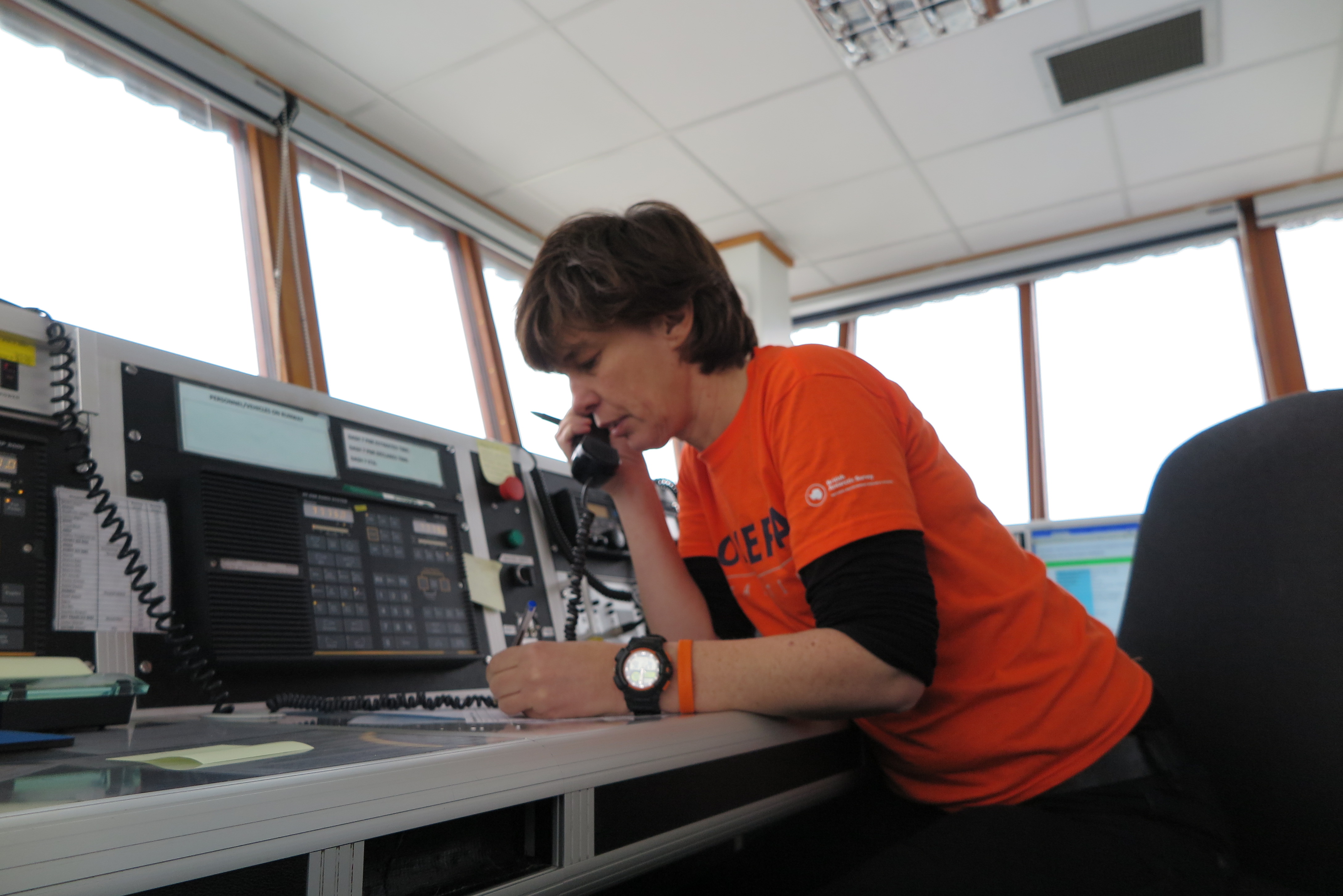
Communication Tower
The computer on the left is used for AFTN flight planning. This is where we submit the AFTN flight plan intentions and update departure and arrival times for each flight. Next week we will be changing to the AFPEX web-based flight planning application https://ts1.flightplanningonline.co.uk/ instead of the UDP based installed Copperchase AFTN client software. This will make the client PC easier to administer and eliminate the need for a dedicated established network link through to Swanick NATS centre.
Also on the left side of the desk are our antenna choosers and rotator.
We have 4 HF antennas. A North-South, an East-West, a Rotatable log periodic and an emergency HF. The emergency antenna is connected directly to our batter powered iCOM ic- 78 which we only use during power downs. The other 3 antenna we can switch between our 3 HF transmitters.
The main console of the desk has our 2 skanti HF sets and the marine and aero VHF units.
The right hand side PC we use to pickup weather observations from the internet and
intranet.
On the right corner of the desk we have our Iridium and Cisco VOIP phones.
A few weeks ago Karen gave me a tour of the communications bench in the electronics workshop, so I got to see some of the HF radio equipment that I will be working with in the tower at Rothera. This week I have been reading the operation manuals for some of HF radios used at Rothera. I will receive further specific training on using the tower radios with the programmed channels when I arrive at the base. This week I am just learning the basic generic operations of the radios.
I am expecting the HF radios in the tower at Rothera to be busy this summer. They are used for flight-following operations, contacting SkyBlu (SBR) and Fossil Bluff (KG) for meteorology reports, contacting field parties, tractor traverse teams and providing a SAR watch.
Meet the HF Skanti TRP 8250-S
The main HF radios in the tower are Skanti TRP 8250-S radios. I really like the look of these radios. The control panel layout is uncluttered, spacious and generous and both the TX and RX frequencies are always displayed. Modern radio interface designers could look and learn.
Skanti TRP-8250S
I have been reading the 02_OPERATION. I have found this video of the radio in operation useful and the guy is actual a bit of a comedian.
These radios will be used for flight following. The approach sheet for pilots using Rothera airfield provides the HF contact frequencies which are 5080KHz USB, 7775KHz USB and 9106KHz USB. No doubt these frequencies will have been assigned fast recall numbers.
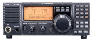
Meet the ICOM IC-78
This radio is used by SkyBlu and Fossil Bluff stations. It is probably too high powered for field party use. The ICOM IC-78 Instruction Manual, is an easy read, the manual is delightfully well written and concise.
ICOM IC-78
This radio has 99 channels to which commonly used frequencies can be assigned. So the first thing I will want to do when I meet this radio is look through the channels to see what frequencies have been assigned to the channels on my new friend.
There a three ways to scroll through the channels, rotating that large dial, pressing the up or down arrow keys or typing channel numbers into the keypad. But this won’t show me the assigned frequency as I scroll through I will only see the descriptive name assigned when the channel was programmed. To see the frequency is assigned to each channel as I scroll through I can press the FC button to see the frequency and if it is duplex number pressing TXF will display the transmission frequency.
To get even better acquainted with the IC-78 in Rothera I will then probably want to look through the setup options that have been configured on my friend. To enter setup mode I will need to press setup, then use the arrow keys to scroll through options, then within an option the large dial could be used to change a setting. So if I only touch the set button and arrow keys and be sure not to touch the dial then I can look through the setup configuration.
Meet the CODAN 2110
This radio is used by science field parties. It is a 25 watt field radio that can be carried in a manpack.
When pilots use an airfield they follow published airfield procedures . I have been learning how Rothera airfield is used and what procedures arriving and departing aircraft need to follow.
The most basic piece of information a pilot needs about an airfield they intend to use is the magnetic heading of the runway. They can’t land sideways onto a runway so obviously they need to know what their compass needs to be pointing as they approach the runway. Because this information is so fundamental it is actually encoded into the number assigned to the runway.
Runway 23-05 Sign @ Cambridge Airport
For example Cambridge airport runs kinda east-west. Approaching Cambridge Airport from the east you need to be heading 230 degrees on your compass to hit the runway directly and approaching from the west you would need to head 050 degrees (180 degrees from 230). Cambridge runway has therefore been assigned runway numbers 05 and 23. The runway number tells the pilot the heading to approach the runway with.
Rothera runway numbers are very easy to remember as the magnetic heading of the runway is straight north-south. The runway numbers assigned are therefore 36 (from the south) and 18 (from the north). The number 36 would be painted in big white numerals at the southern threshold of the runway and 18 at the northern end of the runway.
The Co-ordinates for the thresholds of the two runways are:
Runway 18 67 33.83 South 068 07.40 West
Runway 36 67 34.27 South 068 07.85 West
Clever-pants readers might be wondering why the westerly co-ordinate differs for the two thresholds if the runway runs directly on a north south magnetic heading. The reason is
Rothera Variation 21 degrees East
that the co-ordinates are given in True while the runway is given as a Magnetic bearing. Because of the vicinity to the South Pole there is a significant difference between true and magnetic headings at this latitude. The variation is 21 degrees east. Maps of Rothera runway will show it pointing at one o’clock. But if you stood on the southern end of the runway a compass would point at twelve o’clock.
Runway 18 Lefthand
The circuit direction is also important airfield information . The circuit direction is described as either left-hand or right-hand, according to which way the pilot turns in the circuit. At Rothera there is a large mountain to the west of the runway so the circuit is always to the east of of the runway. This means that Runway 36 has a right-hand circuit and Runway 18 has left hand circuit.
There is unlikely to be a lot of circuit traffic at Rothera. But the circuit direction and circuiting procedure will still be important to pilots because they may choose to do a go-around then come back around circuit or have a problem such as a bird strike during a take-off and want to come around the circuit and land.
Looking West. Circuit is on the east to avoid those mountains.
The circuit height is 1,200 feet. The elevation of the airfield is a tiny 13 feet.
The missed approach point (MAPt) is the point at which a pilot will decided whether they are going to continue into land or execute the missed approach procedure. The Rothera missed approach point RMAPt is 1.5 nm from the runway. The minimum descent altitude(MDA) at the RMAPt is 700 feet.
The local barometric pressure is an important piece of airfield information. Pilots use this information to calibrate their altimeters . Without an accurate pressure a pilot won’t accurately know their altitude(bad). Pressure is typically provided to pilot as hector-pascals for a QNH (pressure msl) or a QFE(pressure at the runway threshold). Because the runway at Rothera is only 13 feet above msl there is very little difference between the QFE pressure and the QNH pressure. The QFE is one hector-pascal lower than the QNH. So I just looked at the current pressure measurement for Rothera and I can see that it is reading 979 hPa. From this I know that the QFE is 979 and the QNH is 980.
Pressure = 979 hPa therefore QFE= 979hPa and QNH =980hPa
The VHF frequency 129.7 MHz is for Traffic Information Broadcast by Aircraft (TIBA) in the region. Pilots will listen to the is frequency and broadcast any pertinent information for other aircraft in the vicinity.
There are various ways aircraft can contact Rothera tower. Rothera is a prior arrangement only airfield so any visiting aircraft will have phoned to make arrangements prior to departing. For long distance contact with Rothera tower from the air pilots have three HF channels 9106.0 kHz, 7775.0kHz and 5080.0kHz. Alternatively the aircraft have Iridium satellite phones and could call the tower on 881 631 831 227. Once closer to the station probably less than 50 miles they should be able to make VHF radio contact on 118.1 MHz from which we would expect a clearer and more reliable connection. We will be listening on all of those communication links in the tower, so I hope that don’t all go active simultaneously.
The official hours of operation of the airfield are 1100 to 0000 Zulu time, Monday to Saturday, October to February. Zulu time is UTC and the time offset at Rothera is UTC-3 (P – Papa time). Converted to local time the operation hours will be 0800 to 2100 local time. But in reality we will work much longer hours than this in the summer if the weather is favourable for flying.
Flying was a very tangible freedom. In those days, it was beauty, adventure, discovery, new worlds.
(Anne Morrow Lindbergh, 1929)
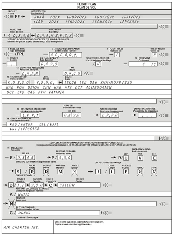
Not any more. The International Civil Aviation Organization (ICAO) was formed in 1947. And today flying is very a regulated and planned activity. Pilots strictly follow ICAO FPL flight plans. All Dash 7 flights in and out of Rothera require the submission of an ICAO FPL flight plan to the global Aeronautical Fixed Telecommunications Network (AFTN) cloud.
One of the computers in the tower at Rothera has been connected to the UK AFTN Parent node located at the CAA London Control Centre in Swanwick . This computer is running an AFTN Terminal Application that can send and receive flight planning and meteorology messages to the AFTN cloud(via Swanwick).
To prepare for a Dash 7 flight we will need to send an FPL flight planning message (based on a template) to the AFTN and record the AFTN message number onto the flight following log sheet. When the flight departs we will send a DEP message to the AFTN and record the message number on the log sheet. Once the aircraft arrives at the destination an ARR message will be sent and logged. We will also be able to use the AFTN terminal to report delays (DLA), send progress report messages, request METAR meteorology reports or if necessary cancel (CNL) a flight plan. If the AFTN terminal fails the backup procedure is to print the FPL form (CA48) and fax the form to Swanwick. We will also receive AFTN messages such as METARs and flight plans and progress updates sent by other stations regarding aircraft in the vicinity.
I will be trained in the specific processes for managing the Dash 7 plans when I arrive on the base, however this week I have been learning generally about UK Flight Planning procedures. Yesterday we visited the operations tower at Duxford Airport and learned about the systems and procedures to submit, activate and progress FPL flight plans via an AFTN terminal. Colin also usefully suggested that I read the CAA UK Flight Planning Guide CAA CAP694.
Nowadays flight plans will almost always be submitted electronically either via an AFTN terminal like they do at Rothera or online via the flight planning webpage . But I found that initially attempting to understand how to complete the paper form and read the raw text FPL messages was a good way to start gaining an understanding of the layout and coding requirements of flight planning AFTN messages.
At first sight the form and message seems quite impenetrable. But of course once you learn the message format and all the codes by heart the form magically transforms from a wad of meaningless gobbledygook-gook into a gloriously concise and precise presentation of a large amount of information.
The remainder of this story will discuss in some detail the individual fields on an FPL message, if that’s not of interest to you then you might want to leave it here. Otherwise, grab a hot drink (you will need it) and let me talk you through the format and coding of a ICAO FPL flight plan message.
The Aircraft Identification code (Callsign) is the first question in the FPL message section of the form. I will need to have the BAS aircraft callsigns at the tip of my tongue when I am working in the tower. The bathroom wall is kindly helping me learn these.
The Flight Rules codes are relatively simple:
I = Exclusively IFR (Instrument)
V= Exclusively VFR (Visual)
Y= Initially IFR but will change to visual during the flight
Z= Initially VFR but will change to instruments during the flight
The Type of Flight codes are straight forward and almost guessable:
S = Scheduled Service
N = Non-scheduled Operation
G = General Aviation.
M = Military
X = Other than any of the defined categories above.
The Number of Aircraft field is left blank unless it is more than one. No codes to learn.
The Type of Aircraft code is the ICAO Aircraft Type Designator which can be looked up in the ICAO DOC 8643. I will need to know the BAS aircraft designator codes without needing to look them up and hence am learning these with the help of the fridge.
ICAO Aircraft Type Designator Codes
The Wake Turbulence Category codes are relatively simple:
H = Heavy > 136,000 kg
M = Medium > 7,000 kg (eg Dash 7)
L = Light < 7,000 kg (eg Twin Otter)
The Equipment field has two parts with a / used as a field separator. On the left side of the / the Radio, Navigation AND Approach Instruments are coded. The letter S can be used to note that the standard equipment including VHF RTF, VOR and ILS is fitted. On the right side of the / SSR transpoder and other surveillance capabilities are noted.
So for example -S/C indicates standard equipment and a mode Charlie transponder.
The Departure Aerodrome code is entered as an ICAO airport code. I unquestionably need to learn these by heart for the airports in the vicinity of Rothera so they get prized position at the kitchen sink.
ICAO airport codes on the wall behind the kitchen sink
If the airfield hasn’t been assigned an ICAO code then ZZZZ can be entered and the name entered manually in the Other Information field preceded by DEP/
And if the aircraft is already in flight then AFIL can be entered.
The Time of Departure is always entered as Z-Zulu time which is UTC.
This time is referred to as the estimated off-block time (EOBT)
The Cruising Speed entered is the cruising True Air Speed and can be entered as :
Knots (e.g. N0215)
or Kilometres (e.g. K0400)
or Mach number, to the nearest hundredth of a mach (e.g. M033)
The Crusing Level can be entered in one of the following formats:
Flight Level(e.g. F230 for Flight Level 230)
Altitude in hundreds of feet (e.g. A230 for 23,000 ft)
Tens of metres on standard atmosphere (e.g. S0700 7000m on 1013)
Altitude in tens of metres, (e.g. M0700 7000m above msl)
or the letters VFR if a cruising level is not planned for the flight
The planned Route section of the form is where the details of planned changes to speed, levels and flight rules will be entered. For us this information will be provided by the Flight Operations Manager and we will enter the details into this section. I might write another post about the format of these plans. It is too much to go into here.
The Destination Aerodrome is entered as an ICAO airport code. I have already discussed ICAO airport codes in the departure aerodrome section so I won’t repeat it.
The Total EET Time is the total estimated elapsed time. It is worth emphasising that this is NOT the estimated time of arrival. This is the total estimated time required between take-off and arriving over the destination aerodrome. The EET is expressed in hours and minute as a 4 digit number. For example a flight with and EOBT of 0900 and an EET of 0130 would have an ETA of 1030 and only the 0900 and 0130 values are included on the form.
The Alternate Aerodrome is entered as the ICAO airport code for the airfield where the pilot will take the aircraft if the destination airfield cannot be reached. For example SCRM (Marsh Airport on King George Island) might be an alternative airfield for a flight to SCCI (Punta Arenas). The FPL plan will appear in the AFTN terminal of the Alternate AIrfield so that they are aware of the information within the plan and can monitor the flight progress updates. Again use ZZZZ and manually enter the name preceded by ALTN/ in the other information field if the alternate airfield has not been assigned a ICAO airport code.
In the Other Information field you can enter a 0 (Zero) if there is no other information. But that will not be the case as a minimum the date of the flight (DOF/) in YYMMDD format will be entered into this section.
It’s also very likely that some information about the IFR instruments and capabilities of the aircraft(PBN/ and NAV/) will be included. These information included in this section will be very specific to the aircraft equipment and routes. I will learn more about what information is included in this section . When I arrive in Rothera. It is perhaps worth mentioning that the coding of this information changed in 2012.
The Supplemental Information is not included in the main FPL message, it is kept at the location where the FPL is filed.
In the Endurance (E/) field enter the fuel endurance in hours and minutes format.
In the Persons On Board ( P/) field enter the total number of passengers and crew if this is not known at the time the plan is submitted you can enter TBN.
The three Emergency Radio (R/) check-boxes should be reviewed and crossed out with a large X if the aircraft is not equipped with the relevant radio. If the aircraft does not have UHF on frequency 243.00 MHz then put a cross through the U box. If the aircraft does not have VHF on frequency 121.500 MHz then put a cross through V box (but this is very unlikely). If the aircraft does not have an emergency location transmitter (ELT) then put a cross through the E box.
The four Survival Equipment (S/) checkboxes should also be reviewed. Put an X through the P if polar survival equipment is not carried. Put an X through D if desert survival equipment is not carried. Put an X through M if maritime survival equipment is not carried.
And put an X through J if jungle survival equipment is not carried.
The three Jackets (J/ ) checkboxes should be reviewed.
Put an X through L if life jackets are not equipped with lights.
Put an X through F if life jackets are not equipped with fluorescein.
Put an X through U and/or V; as in R/ (above) to indicate radio capability of
jackets, if any.
In the Dinghies (D/) section put an X through both D and C if no dinghies are carried. If Dinghies are carried enter the number of dinghies carried and total capacity, in persons, of all dinghies together. Put an X through the C if the dinghies are not covered and enter the colour of the dinghies.
In the Aircraft Colour and Markings (A/) enter the colour of aircraft and any significant markings.
If you don’t need to enter any special Remarks (N/ ) Simply put a X through the N . You may however use this field to make remarks regarding survival equipment on the aircraft.
In the Pilot field (C/) enter the name of the pilot-in-command.
The Message Header
The FF header section at the top of the paper form isn’t strictly a part of the FPL message. A header would be needed for any message (eg ARR DEP). This informs the routing of the message that follows, much like the header in an email.
In the header you need to specify the message recipients (destinations), sender (originator) and the filing time in the header section of the
The Message Header Destination Addresses are AFTN addresses. These are eight characters long made up of:
– A four-letter ICAO Location Indicator (on the kitchen sink wall)
– A three-letter-group identifying a specific service area . I have not yet found a definitive list of these code but below are the examples cited on wikipedia:
YFY = AFTN Office
ZTZ = Control Tower
ZPZ = ATS Reporting Office
ZQZ = Area Control Centre
YNY = Notam Office
YDY = Airport Manager
YZY = Met Data Bank
YMY = Local Met Office
ZRZA = Radar Approach
– The 8th character is an additional letter to identify a department or process within the service area . The letter X is used if the department is not needed.
So for example the destination address for the Tower at Mount Pleasant Airport in the Faulkland Islands might be EGYPZTZX. Another example could be SCRMZQZX for Area Control at Marsh Airport.
The Filing Time is format is DDHHMM(Zulu). So for example 190836 means that the message was filed on the 19th day of month at 08:36 UTC time.
The Originator Address will use the same format as I just talked about for the recipient but obviously this will be the address of the message sender.
To top-off our air-ground radio training we were fortunate to be invited to visit the Radio Communications tower at Duxford Airport. This was incredibly useful in terms of seeing flight planning, meteorology report passing and tower operations in action. Colin and Peter were most generous with there time and knowledge.
Colin and Pete explained the numerous systems and software they use in the Tower.
One of the scarier sounding jobs I will be doing at Rothera will be submitting formal FPL flight plans into the AFTN terminal for Dash 7 flights. I don’t really know the reason why plans are required for the Dash 7 flights but not the Twin Otter flights. It might be because the Dash weighs more than 5,700 kg, while the Twin Otters weigh less. It was great to see the AFTN software being used at Duxford. Colin gave us a very helpful and thorough walk-through of the coding, submission and updating of a flight plans via the AFTN software. The flight plans are very code heavy messages and at first sight seem quite impenetrable.
Duxford tower operations also pass a lot of meteorological reports to and from pilots. During our visit a Catalina PBY took off and departed up through the cloud ceiling. Colin collected and relayed a meteorology report from the Catalina pilot as he left the airfield.
Colin taking a met report from the Catalina PBY
Colin also took us through the process of decoding, translating and reading out meteorological reports and forecasts from the TAFs and METARs he downloads twice hourly from the Met Office Aviation Briefing Service.
As a radio operator at Rothera Station I will be doing aircraft flight-following. This means that I will be taking regular position and meteorology reports from BAS pilots and in return giving them meteorology reports and any other information they require about the airfields and areas they are flying towards.
In the UK Ofcom are the officialdom custodians of the radio frequencies. For the air band frequencies Ofcom delegate responsibility for training and licencing of operators to the Civil Aviation Authority (CAA). The CAA recognise three levels of ground to air radio service/licence. The highest level is air traffic control (ATC), then flight information service (FISO) and thirdly the much more basic air-ground radio (AGCS). Rothera base offer just the basic air-ground radio service. To operate the radio service at Rothera station it is appropriate for me to hold a CAA AGCS Radio Operators Certificate of Competence. Obtaining this licence involves passing both a written and a practical exam. The theory exam covers all of the material in CAP 452 Aeronautical Radio Station Operators Guide and the sections of CAP 413 Radiotelephony Manual relevant to the air ground radio service and take a practical exam.
BAS run a course each year to train and licence the radio operators for the upcoming season. I spent my first week working for BAS on this course. This was hands-down one of the best training course I have ever attended. Paul is a Senior Air Traffic Controller at Stansted Airport. He has been providing this training for BAS for many years and it shows. The course is very well structured and paced.
The first morning was spent summarising the theory material that ideally you will have self-studied before the course. Then we started talking on the radio.
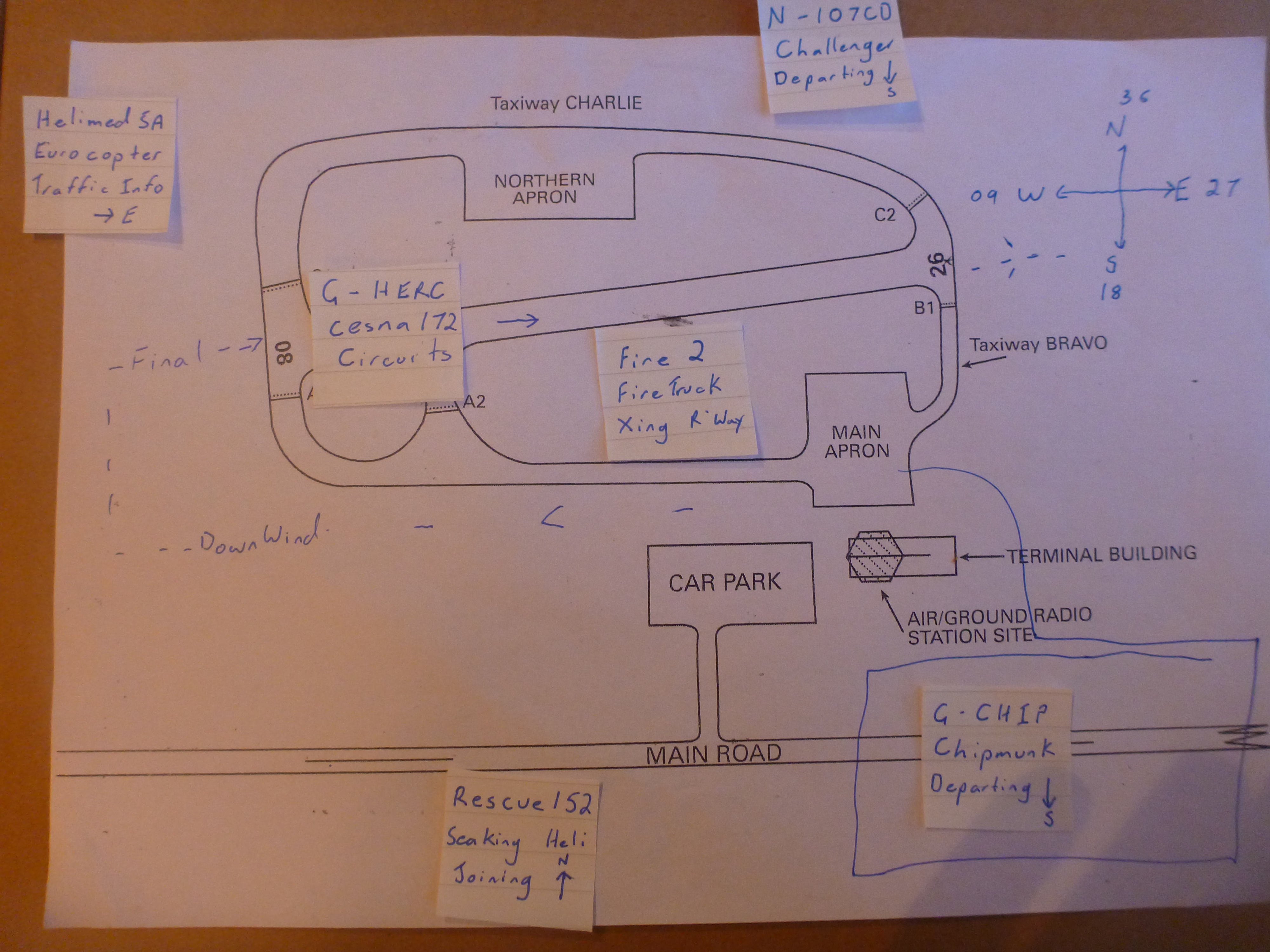
Paul has a tidy set of kit that he uses to run the practical practice sessions. We students sit in a cubical wearing a headset, we have a PTT button to transmit and the local pressure, wind and circuit information is posted on the booth wall as it would typically be in a radio office. Paul sits outside the booth with a unit connected via a serial cable and pretends to be various aircraft.
The first practicals was a straight forward communication with a single aircraft on the apron preparing to depart. The second practical was also just an single aircraft, this time an incoming aircraft wanting to join the circuit to land.
On the second day of the training Paul started increasing the number of aircraft involved and the types of requests. By the afternoon he had us handling more than five aircraft and responding to a Mayday distress call in amongst it.
A key piece of information that radio operators pass to aircraft is information about other pertinent traffic in the vicinity. So for example if a pilot reports that they are about to depart the airfield or cross the runway it is useful to tell them if there is another aircraft on final approach to land. Similarly if an aircraft intends to join the circuit to land it is useful to make the pilot aware of any traffic ahead of them in the circuit so they can watch out for it. To do this the radio operator has to keep track of the position of all traffic in the vicinity. It was clear very quickly that I wasn’t going to be able to do this in my head so I designed a system to visually track the traffic. For each new aircraft I would write up a small card contain the aircraft callsign, type, destination and heading, and each time the aircraft reported a new position I would move the card to the appropriate position on a diagram of the airfield.
The third day was practice and refinement of our skills and techniques and an introduction to meteorology reporting(more on met later in a different post).
By Thursday we all felt ready to take our exams. The theory course at 10.00am then the practical in the afternoon. Everyone passed.